
Centered around the 45th parallel of the northern hemisphere and described either as a country of the Balkans, or as a southeastern European country,
Romania offers a lot of geographical contrasts.

The Carpathian Mountains, covered with dense forests, enclose the Transylvanian Plateau in a wide arc, a distinctive feature, evident at first glance on any map of Romania. On the outside of this arc, the Moldavian Plateau stretches to the East and the Walachian Plain to the South.
The country covers an area of 91.669 square miles. It is comprised in almost equal proportions of plains, hills, plateaus and mountains.
Bordering countries are: Moldavia and the Ukraine, two former republics of the now defunct Soviet Union, to the East and North, Hungary to the North-West, Serbia of former Yugoslavia to the South-West and Bulgaria to the South. Romania also has 150 miles of coastline on the black Sea to the South-East.

The Carpathians, divided as Eastern, Southern and Western Carpathians, average 4,000 feet in height. Their composition offers a rich geological diversity of sedimentary, metamorphic and volcanic rocks. The highest peaks are Moldoveanu and Negoiu (more than 8,300 feet) in the Fagaras Mountains, of the Southern Carpathians. The mountains are crossed by many rivers: the Olt, the Mures, the Prahova, the Bicaz, which create beautiful valleys and canyons, such as Turnu Rosu in the Olt valley and spectacular gorges like the Bicaz Gorge, in the Eastern Carpathians. There are also marvelous caves, the most famous being “Pestera Ursilor”. The mountains hold granite and basalt quarries, as well as lead, bauxite, iron ore, copper ore, gold and uranium mines.
Enclosed by the massive walls of the Carpathians, there are depressions, which played an important role in Romanian history. Romanians named them “countries” (the Oas Country, the Moti Country, the Olt Country, the Maramures Country) even though they have never had any political, social or administrative status.
The Subcarpathians form the transition between the Carpathians and the plains. The high hills offer good conditions for orchards, vineyards and hay-making. The soil is rich in coal, salt and oil.
Some of the Romanian plateaus, such as the Transylvanian Plateau, are in te center of the Carpathian arc, others, such as the Getic Plateau, the Moldavian Plateau, the Dobrudja Plateau are on the outside. They are generally covered with beech and oak forests, and vineyards on the gentler slopes. It is on these plateaus, where the famous Cotnari, Odobesti, Tarnave and Murfatlar vineyards are located.
The Romanian or Wallachian Plain is surrounded by the Carpathians to the West and North, by the Danube River to the South and by the Dobrudja Plateau and the Prut River to the East. It is the “bread-basket” of the country, formed mostly of layers of loess and alluvial soil. On the eastern part of this plain there are some sand dunes, salt lakes and the Baragan steppe, some of which was converted into arable land. The Western or Banat Plain in the West is smaller than Wallachian Plain.

Covering an area of 1,500 square miles the Danube Delta in the East of the country is a unique ecosystem in Europe. It is an extraordinary natural reservation consisting of marshes, sand banks and floating reed islands, crossed by hundreds of water channels.
Almost all major rivers of Romania flow into the Danube which is the largest river of the country and one of the largest in Europe. It forms the natural border to Serbia, Bulgaria and the Ukraine. It is an important water route for domestic and international ships. A powerful hydroelectric plant was built in 1972 at the Iron gates straits, where the Danube dug a narrow canyon across the Carpathians, to make its way toward the Black sea.
Other major rivers are the Olt, the Somes, the Mures, the Jiu, the Prut and the Siret, some of them being used for local transportation or logging. Most of the hydroelectric potential of the rivers is being utilized. Mineral springs with therapeutic properties have been long in use at Baile Herculane, Baile Felix, Tusnad, Vatra Dornei, Olanesti, Calimanesti, etc. Many health resorts were built in these areas.
Romania’s considerable diversity of fauna and flora derives from the complexity of the relief. One can distinguish the following three vegetation zones: alpine, forests and steppe.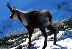
The alpine zone begins at about 5,500 feet and consists of mountains pines, small bushes and shrubs scattered on mountain meadows. The fauna is represented here by the bearded vulture and the chamois.
Capercaillie (Tetrao urogallus), the knight of the mountines hights.

Romania’s forests cover more than 25% of the land. The coniferous forest is intermingled with birches and maples at lower altitude. The Transylvanian Plateau is covered with oak and beech trees. Large oak forests can also be found in Dobrudja, in the Western Plain, across the northern part of the Wallachian Plain and in southern Subcarpathians. Large numbers of deer, wolves, bears, lynxes, squirrels, hawks and owls roam these forests.
The steppe, although mostly cleared for agriculture, can still be found East of Bucharest and in the southern Dobrudja. It is the land of hares and bustards.
The Danube delta has a special vegetation of reeds and sedges and thousands of birds come here every year.
Romania’s climate is temperate-continental, with some local variations produced by the diversity of relief. The hottest months of the year are July and August, with the average temperature of 85° F and the coldest month is January with 25° F. The Carpathians affect the humidity and the winds causing weather modifications. The Mediterranean influence in Romania’s south-west and in southern Dobrudja results in mild winters and hot and dry summers.
(by now this is just theory as we experience extremes much over 104° F and below 5° F with sudden changes from could to warm and leading to lots of floods and other disasters!!!!)

Administratively Romania is divided into 42 counties (judete). Bucharest, the capital, is the most important political, economical and cultural center of the country. It is situated on the Dambovita River in the south-eastern part of the Wallachian Plain, and is surrounded by many natural lakes and forest. Other major cities are: Cluj, Timisoara, Jassy (Iasi), Constanta, Brasov, Sibiu, Arad, Oradea. There are several port cities such as Sulina, Galati, Giurgiu, and Orsova on the Danube, and Constanta on the Black Sea.
The population of Romania is approximately 23 million. Romanian-speaking people represent about 86% of the population. As ethnic minorities, Hungarian and Germans live mainly in Banat and Transylvania, Serbians in Banat, and Jews throughout Romania. The Gypsies form one of the largest ethnic groups. Some of them live a nomadic life, others are settled near large cities like Bucharest and Constanta. A limited number of Russians, Bulgarians and Turks live in Dobrudja, Ukrainians in Maramures and northern Moldavia.

0 Comments:
Post a Comment
<< Home